The National Center for Meteorology in Saudi Arabia issued its daily report on the expected weather conditions for Friday, warning of continued weather fluctuations and thunderstorms that may reach heavy levels over large parts of the Kingdom, including 12 regions, which increases the likelihood of flash floods in valleys and ravines.
Details of the rainfall situation and affected areas
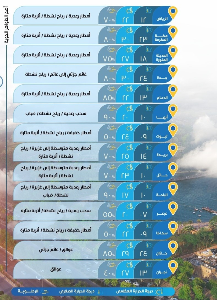
According to the center's statement, thunderstorms of varying intensity, ranging from moderate to heavy, are expected, accompanied by hail and strong winds that will stir up dust and sand. These winds may lead to near-zero horizontal visibility in the regions of Riyadh, Makkah, Madinah, Al-Baha, Qassim, Hail, the Northern Borders, and the Eastern Province . Light to moderate rain is also expected in parts of the regions of Al-Jawf, Tabuk, Asir, and Jazan .
The climatic context of the weather situation
This rainfall is occurring during a climatic transition period in the Arabian Peninsula, where the region is affected by low-pressure systems originating from the Mediterranean and Red Seas, which converge with humid air masses. This period is characterized by an increased likelihood of cumulonimbus cloud formation, leading to heavy rainfall over short periods. Historically, many areas of the Kingdom, particularly the southwestern highlands and the central and northern regions, experience similar rainfall patterns during the spring and autumn seasons, known locally as "Al-Wasam" and "Al-Sarayat.".
Importance and expected effects
Locally, these rains are of great importance; they contribute to replenishing groundwater reservoirs and revitalizing vegetation and pastures, which is vital in a desert environment. However, the heavy rainfall poses a significant challenge, increasing the risk of flash floods, especially in mountainous areas and valleys. The General Directorate of Civil Defense has issued repeated warnings to citizens and residents to exercise caution, stay away from floodplains and valleys, and avoid crossing them during rainfall. The weather conditions are also expected to affect land and air transport in some areas due to reduced visibility and strong winds.
The situation in the Red and Arabian Seas
Red Sea
- Surface winds: Northwesterly to northerly in the northern and central parts, and southeasterly to southwesterly in the southern part, with speeds ranging between 15-35 km/h, and may reach more than 50 km/h with the formation of rain-bearing thunderclouds.
- Wave height: from half a meter to one and a half meters, and may reach more than two meters with thunderstorms.
- Sea state: Light to moderate waves, and may be rough with thunderstorms.
Arabian Gulf
- Surface winds: Northwesterly to northeasterly, turning easterly then southeasterly at night, with speeds ranging between 12-30 km/h.
- Wave height: from half a meter to one meter.
- Sea state: Light to moderate waves.