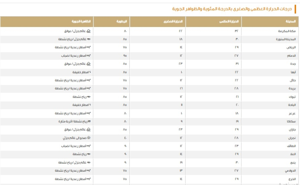
Weather forecast in Saudi Arabia: Widespread weather fluctuations
The National Center for Meteorology in Saudi Arabia issued its daily weather report, forecasting continued weather fluctuations across most of the Kingdom on Tuesday. The forecast indicates thunderstorms of varying intensity, accompanied by active winds that may reach speeds of up to 200 degrees Celsius, causing dust storms and reducing horizontal visibility in several key areas.
These weather conditions are occurring during a transitional period in the Arabian Peninsula, where the region is affected by low-pressure systems that contribute to the formation of thunderstorms. This period is known locally as being close to the "Sarayat" season, which is characterized by rapid and sudden weather changes, necessitating continuous monitoring of warnings issued by the relevant authorities to ensure public safety.
Geographical details of rainfall and wind conditions
According to the weather report, there is a chance of thunderstorms accompanied by strong winds that will stir up dust and sand across large parts of the Northern Borders region, the Eastern Province, Riyadh, Qassim, and Hail. The effects will also extend to parts of the Madinah and Makkah regions. These strong winds may significantly reduce visibility, posing a danger to drivers on highways.
In contrast, the sky will remain partly cloudy in the southwestern highlands, with a chance of light rain over parts of the highlands in the Al-Baha, Asir, and Jazan regions. The center did not rule out the possibility of fog forming during the night and early morning hours over parts of these highlands, as well as parts of the Tabuk and Eastern regions, requiring extra caution.
Weather conditions on maritime navigation
Red Sea situation
Surface winds over the Red Sea will be northwesterly to northerly in the northern and central parts, with speeds ranging from 12 to 42 km/h. In the southern part, winds will be southerly to southeasterly at speeds of 20-45 km/h, potentially increasing to 55 km/h towards the Bab el-Mandeb Strait. Consequently, wave heights will range from half a meter to one and a half meters in the north and central regions, and from one to two meters in the south, reaching over two and a half meters at the strait, resulting in a moderate to rough sea state in that area.
Arabian Gulf situation
In the Arabian Gulf, surface winds will be southerly to southeasterly in the northern and central parts at speeds of 12-42 km/h, with the possibility of reaching 50 km/h during thunderstorms. Wave heights will range from half a meter to one and a half meters, potentially exceeding two meters during thunderstorms. Therefore, sea conditions will be slight to moderate, becoming rough in areas affected by thunderstorms.
Special warning for the Eastern Province
The center issued an advanced warning for the Eastern Province, cautioning of blowing dust and moderate rain. The dust storm will begin in Qaryat Al-Ulya Governorate at 9:00 AM and continue until 6:00 PM, accompanied by strong winds and near-zero visibility. Moderate rain is expected in Al-Khafji, Al-Nairiyah, Qaryat Al-Ulya, and Hafr Al-Batin Governorates from 7:00 AM until 4:00 PM, potentially accompanied by strong winds, hail, and thunderstorms.