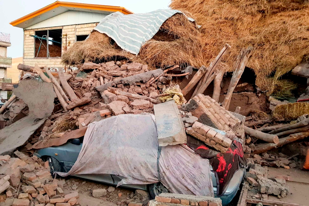
A series of earthquakes struck Yazd province in central Iran on Friday morning, causing widespread concern among residents. Three earthquakes hit the town of Behabad within minutes, with the strongest measuring 5.1 on the Richter scale. Emergency teams were immediately dispatched to assess potential damage.
According to the Iranian Seismological Center, the first earthquake, measuring 4.9 on the Richter scale, struck at 11:01 a.m. local time, at a depth of 15 kilometers. Just three minutes later, a stronger aftershock, measuring 5.1, followed at a depth of 12 kilometers, further intensifying the panic. A third aftershock, measuring 3.2 on the Richter scale, was also recorded in the same area at a depth of 8 kilometers. Following these tremors, local authorities announced that teams from the Iranian Red Crescent had been dispatched to villages and areas near the epicenter to assess the situation and provide necessary assistance.
Iran lies on a seismic fault line
This seismic activity serves as a constant reminder of Iran's sensitive geographical location. The country sits atop several major tectonic plates, most notably the Arabian Plate, which is moving northward and colliding with the Eurasian Plate. This ongoing collision makes Iran one of the most seismically active countries in the world, with its territory crisscrossed by a complex network of active faults that cause thousands of earthquakes annually, most of which are minor and go unnoticed by the population.
A history of devastating earthquakes
Iranian history is marked by a painful record of devastating earthquakes that have caused immense human and material losses. Perhaps the most notable was the 2003 Bam earthquake, which measured 6.6 on the Richter scale and claimed the lives of over 26,000 people, almost completely destroying the historic city. Iranians also vividly remember the 1990 Manjil-Rudbar earthquake, which measured 7.4 on the Richter scale and is considered one of the worst natural disasters in the country's history, resulting in the deaths of approximately 40,000 people. These tragic events prompted authorities to attempt to improve building standards and develop emergency response plans; however, rural and remote areas still face significant challenges in this regard.
Importance and expected impact
Although the earthquake that struck Bahabad was of moderate strength, its significance stems from its location in a densely populated area, raising concerns about its impact on older buildings and less resilient infrastructure. The occurrence of a series of tremors within a short period (a seismic swarm) increases the anxiety among experts and residents regarding the possibility of a larger earthquake. Domestically, this event serves as a test of the rapid response capabilities of Iranian emergency and rescue teams. Regionally and internationally, it underscores the urgent need for collaboration in earthquake studies, the development of early warning systems, and the provision of technical support to countries located along the "Ring of Fire" to enhance their capacity to cope with natural disasters.